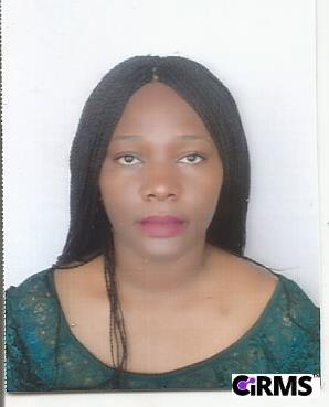
Uzoma Chinenye Okeke
Uzoma Chinenye Okeke is a LECTURER I in SURVEYING AND GEOINFORMATICS Department, Faculty Of Environmental Sciences in Nnamdi Azikiwe University

|  |
Staff Profile
I am Uzoma Chinenye Okeke. I am a Registered Surveyor lecturing in the Department of Surveying and Geoinformatics with Geodesy and Geodynamics as my Area of specialisation
Personal Information
Email: | |
Phone: | |
Address: | Surveying And Geoinformatics, Faculty Of Environmental Sciences, Nnamdi Azikiwe University, Awka. |
Faculty/Unit: | FACULTY OF ENVIRONMENTAL SCIENCES |
Department/Sub-Unit: | SURVEYING AND GEOINFORMATICS |
Social Profiles
Academic Qualifications
| Degrees / Basic Certificates | |
|---|---|
| 1 | Nnamdi Azikiwe University, Awka. (Master Degree, August, 2014) March, 2011 to August, 2014 MSc Surveying And Geoinformatics Surveying And Geoinformatics |
| 2 | Nnamdi Azikiwe University, Awka. (Bachelor Degree, August, 2007) October, 2002 to July, 2007 B. Sc Surveying And Geoinformatics Surveying And Geoinformatics |
Creative Output
| Journal Articles | |
|---|---|
| 1 | Okeke Uzoma Chinenye, Ono Matthew Nnonyelum. (2024, October), "Anambra state regional geoid determination using satellite altimetry", International Journal of Multidisciplinary Research and Growth Evaluation, Vol. 5, (Issue 2), pp 537-546 |
| 2 | Okeke Uzoma Chinenye, Ono Matthew Nnonyelum. (2024, October), "2. Spatial-Temporal Variability of Anambra State Regional Geoid Using Satellite Altimetry", International Journal Of Engineering Research And Development, Vol. 20, (Issue 10) |
| 3 | Mfoniso Asuquo Enoh, Uzoma Chinenye Okeke, Baywood Cecilia Nkechi. (2023, May), "Mapping and simulating the spatial-temporal changes in the Lagos wetland ecosystem: A step-by-step approach to creating a carbon-neutral, sustainable urban city", Unknown Journal or Publisher |
| 4 | Mfoniso Asuquo Enoh, Richard Ebere Njoku, Okeke Uzoma Chinenye. (2022, July), "Modelling and mapping the spatial-temporal changes in land use and land cover in Lagos: A dynamics for building a sustainable urban city.", Advances in Space Research |
| 5 | Chukwubueze Onwuzuligbo Uzoma Chinenye Okeke, Onah Emmanuel Udochukwu, Iyam Ubi Effiom, John-Uri Kikpoyekeke Uzoma Chinenye. (2022, November), "Modelling Urban Sprawl of the Greater Port Harcourt City Using Remote Sensing and Geographic Information System Techniques", Earth Science Malaysia |
| 6 | Enoh M. A., Okeke F. I., & Okeke U. C. (2021).. (2021, April), "Automatic Lineaments Mapping And Extraction In Relationship To Natural Hydrocarbon Seepage In Ugwueme, South-Eastern Nigeria.", Geodesy and Cartography, 47(1), 34-44. |
| 7 | Mfoniso Asuquo Enoh, Uzoma Chinenye Okeke, Needam Yiinu Narinua. (2021, December), "Identification and modelling of forest fire severity and risk zones in the Cross–Niger transition forest with remotely sensed satellite data", The Egyptian Journal of Remote Sensing and Space Science |
| 8 | Enoh M. A., Okeke U. C., & Barinua, N. Y. (2020).. (2020, October), "Modelling And Delineation Of Hydrocarbon Micro - Seepage Prone Zones On Soil And Sediment In Ugwueme, South Eastern Nigeria With Soil Adjustment Vegetation Index (SAVI).", International Journal of Plant & Soil Science, 32 (13), 13-33. |
| 9 | Prof Igbokwe J. I., Ibe U. C, Ejikeme J. O, Igbokwe E. C. (2016, May), "Spatial – Temporal Mapping And Analysis Of Agulu-Nanka Gully Erosion Site In Anambra State, Nigeria.", Nigerian Journal of Surveying and Geoinformatics, 5 (2): 45-49. |
| Thesis | |
| 1 | Ibe U. C.. (2014, July), "4. Analysis Of Spatial And Temporal Dynamics Of Gully Erosion In Agulu-Nanka Area At Anambra State Nigeria". |
| Projects | |
| 1 | Ibe U. C, Enujiugha A., Ugwulebo B. A., &. (2007, June), "Application Of GIS To Bathymetric Survey". |
Membership of Professional/Relevant Bodies
| 1 | Full Member, "Nigerian Institution of Surveyors" (member since 2012), https://nisngr.net |